

By DANA TIMS/Lincoln Chronicle
Drew Roslund knows very well that the more than 1,500 tourists and others who stay at the two Yachats-area motels he operates may know very little about their oceanfront surroundings.
Knowing where to shop and dine, for instance, are likely to be completely foreign to many guests, many of whom are first-time visitors to the central Oregon coast.
Topping any of those concerns, however, is educating motel guests about where to go in event of a worst-case scenario — a large tsunami hitting the area shortly after an earthquake strikes.
Which is why Roslund and a handful of other coastal hotel and motel operators are participating in a pilot project aimed at giving guests the information they need to perhaps save their lives.
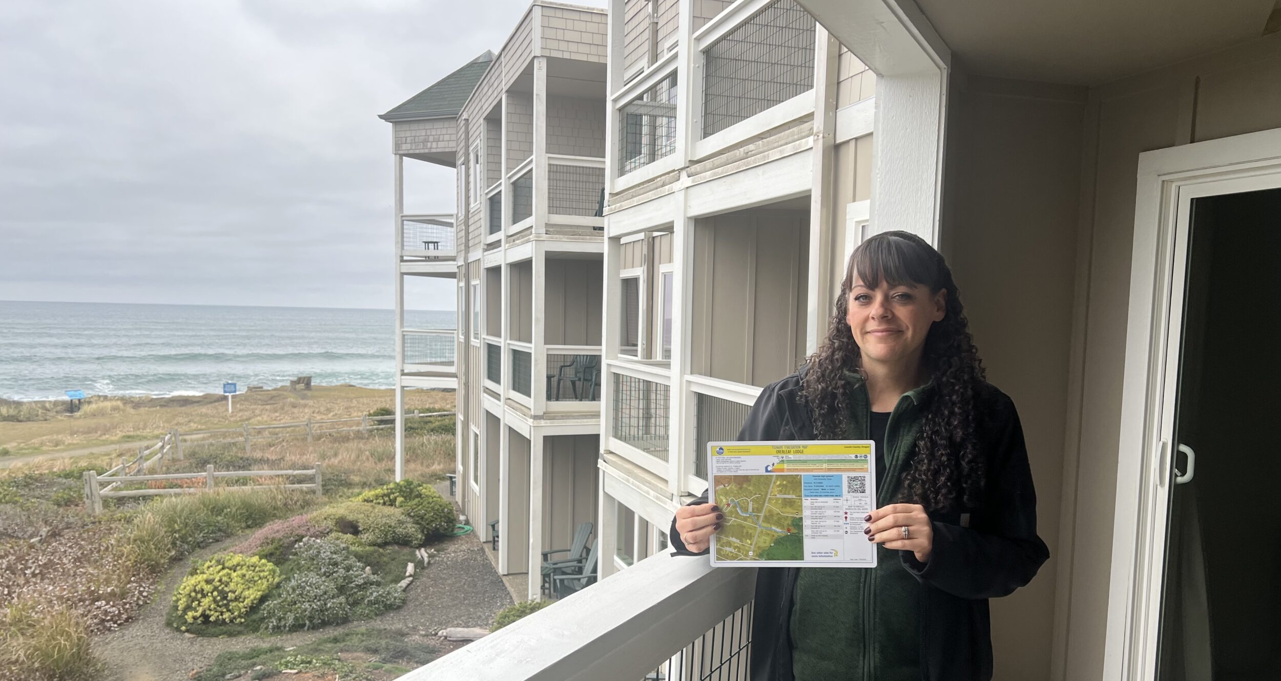
Each room at the Overleaf Lodge and Spa and the Fireside Motel now feature laminated, double-sided maps showing both the so-called “inundation zones” that likely will be covered by in-surging ocean waves and the shortest route visitors need to take to find the safety of higher ground.

“Our perspective is that if people are visiting Oklahoma City in the Midwest, it would be great to provide them information about what to do if there are tornadoes,” Roslund told the Lincoln Chronicle. “That’s basically exactly what we are doing here.”
If an earthquake-generated tsunami does strike off the Oregon coast – as has long been predicted – the time for educating coastal visitors will have past, he said.
“If it’s a pretty significant event, no one is going to have a whole lot of time to get to an area above the inundation zone,” Roslund added. “But with the maps we are providing, folks will have plenty of opportunity to get across the highway and up to safety.”
The project is being spearheaded by the Oregon Department of Geology and Mineral Industries. It is building on work – and a detailed website — released several years ago showing evacuation routes for every segment of the state’s nearly 400 miles of coastline. All people have to do anyone along the coast is log onto the site, put in their address and see their route to safety.

“We’re really excited about this,” said Laura Gabel, the agency’s Newport-based coastal field geologist. “We have so much great data that we’ve pulled together and this is part of our doing our best to get it out there.”
Gabel and her colleagues are working with central coast hotels and motels to get as many of the maps into rooms and lobbies as possible in coming months.
“Visitors to the coast may have very little idea about the surrounding landscape and possible escape routes if a tsunami occurs,” she said. “We are trying to take all the guess work out of it.”
Time to move
Tsunamis, according to agency research materials, are the “first cousins” to earthquakes, and can travel across the deep ocean at speeds of up to 500 miles per hour. That means a tsunami occurring offshore from Japan or Alaska might take up to several hours to hit the Oregon coast.
A tsunami striking along the Cascadia subduction zone off the coast, however, could hit in less than half an hour, making every second valuable in efforts to scramble to safety.
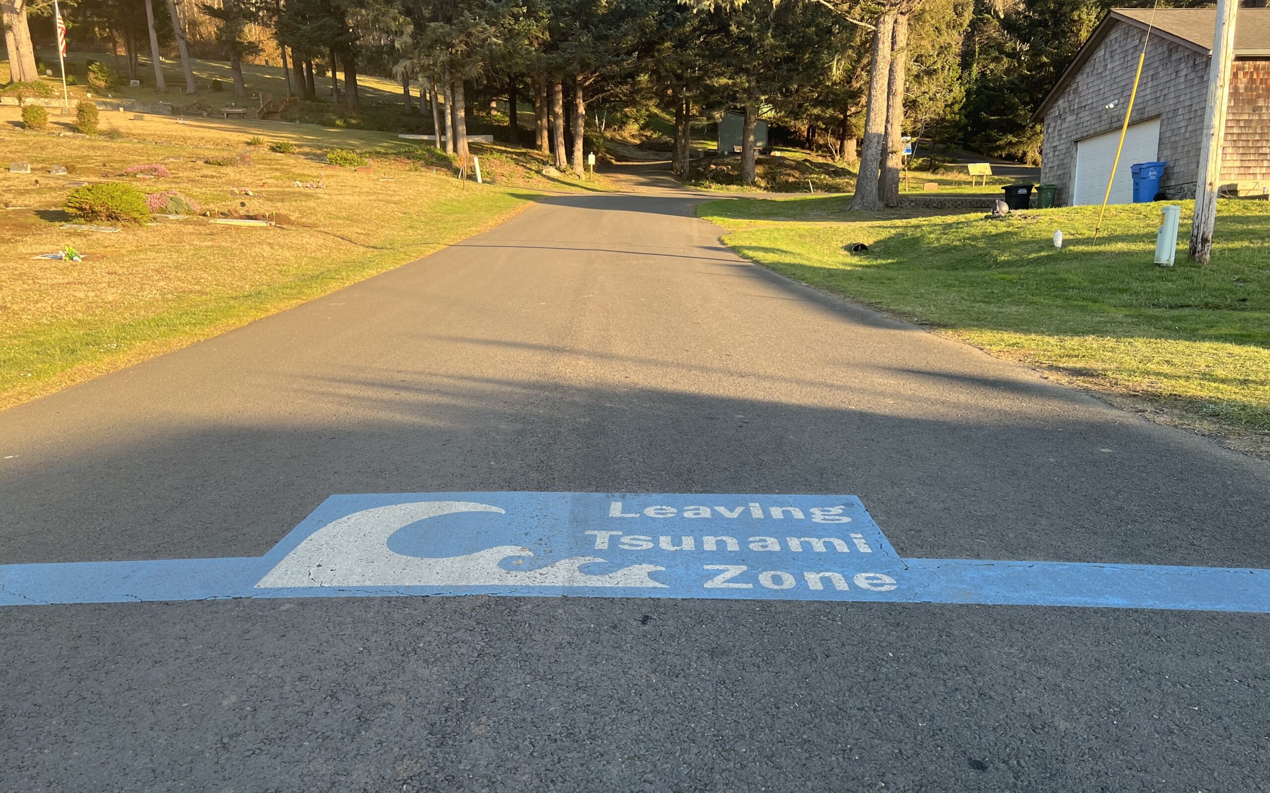
“In most cases, the inundation zone is not wide,” Gabel said. “It’s just a matter of understanding where to go. In an area like Yachats, getting to higher ground is very achievable if you just know where to go.”
In Yachats, for instance, all of the area lying west of U.S. Highway 101 is expected to be inundated even from a smaller, more localized tsunami. But moving just a few city blocks uphill on the east side of the highway will be sufficient to reach identified safe-gathering areas.
“The in-room maps we’re providing will be very easy to understand and use,” Gabel said. “And, so far, the reception has been great.”
The main concern Roslund has heard about the maps is a question of the larger safety issues they are describing.
“That’s the one thing we’ve heard,” he said, “will people see these and get scared?”
His answer is simple and straightforward.
“Maybe,” Roslund said. “But our duty is to protect our guests and staff. That certainly comes before the possibility of losing a room or two for that. We’ve basically pooh-poohed that argument against distributing the maps. People can read through it and get educated on what might happen. Yes, the likelihood is pretty low, but it’s still a possibility. Having the information to deal with that, we think, is a pretty great thing to provide.”
- Dana Tims is an Oregon freelance writer who contributes regularly to Lincoln Chronicle, formerly YachatsNews, and can be reached at DanaTims24@gmail.com
-
To get your Oregon coast tsunami evacuation map, go here


I’ve lived at the coast now for almost eight years since I retired and moved back to my native Oregon after a career as a science writer specializing in writing about seismology and earthquakes. This is an excellent step the motels and hotels are taking but the coast remains woefully unprepared.
A lot has been written in recent years about the concept of strategic retreat and what is essentially forced migration away from coastal areas threatened by hurricanes and storm surges and from other areas subject to severe disasters due to climate change. I believe we need to start talking about long-term strategic retreat from tsunami zones, meaning discouraging residential development in the tsunami zones.
This is obviously a tough problem because of the severe housing shortage and the paucity of developable land between the forest and the sea. But over time, officials should seriously consider measures to turn vulnerable areas now occupied by aging housing into things like parks, golf courses and other recreational sites that do not have overnight residents.
I know this sounds radical, but it can be accomplished over the long term if officials have the guts to refuse to allow new construction in tsunami zones, if financial incentives can be developed to discourage such development and if state land use laws are altered so that some areas now barring development could be opened up.
If we don’t deal with the problem of schools, police stations, businesses, homes etc. in the tsunami zone, the future tsunami will do it for us, with extremely deadly results. See Japan 2011.