

By ALEX BAUMHARDT/Oregon Capital Chronicle
If the once-every-500-year Cascadia Subduction Zone earthquake doesn’t do enough damage to the coastal Northwest on its own, frequent and widespread flooding from rising seas that follows will take care of the rest, new research is suggesting.
Oregon, Washington and California are susceptible to a potentially recurring seismic event — popularly referred to as “The Big One” — which last occurred in 1700 and could cause Northwest coastlines to lower and retreat by more than 6 feet as land erodes into the sea.
Coupled with rising seas from climate change, many more coastal communities will essentially be on top of newly created floodplains and tidal zones amid rising waters.
The findings from researchers at Virginia Tech, the University of North Carolina, the University of Oregon and scientists at the U.S. Geological Survey were published last week in the Proceedings of the National Academy of Sciences.

They found that if The Big One were to occur in 2100, when waters along the Pacific coastline might be three feet higher than today as global ice sheets melt, it’s likely 6.6 feet of Northwest coast would subside into the sea.
That means more than 17,000 people in the region would soon be living on top of expanded coastal flood plains, double the number currently living in such flood zones today.
Researchers’ modeling shows that triple the number of structures, such as hospitals, airports and water and electricity plants, as well as roads, would be exposed to frequent flooding in the aftermath as are today, and could remain that way for centuries.
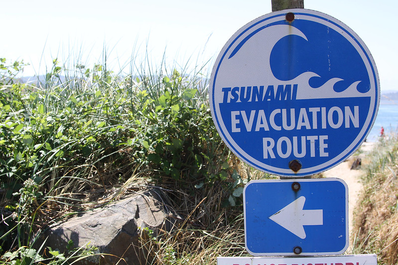
“One of the best ways to think about it is that you could have a coastal forest or a salt marsh that you’re walking your dog along, and then this earthquake happens, and that land, physically, almost instantaneously, in a few minutes, subsides, potentially half a meter to almost 2 meters,” said Andrea Hawkes, a professor of earth and ocean sciences at the University of North Carolina in Wilmington who worked on the study.
“All the sudden, instead of standing on dry land, you are now in the tidal zone.”
Mega earthquakes
It’s not just a hypothetical. The study mentions several historical earthquakes that led to fundamental changes in coastal landscapes and the loss or relocation of whole towns.
The Great Chilean Earthquake of 1960 — the biggest ever recorded at a magnitude of 9.5 — caused more than 8 feet of coastal land in some parts of the country to slide into the sea, submerging pine forests and farms underwater and turning them into tidal marshes.
The Great Alaska earthquake in 1964 lowered coastal areas by more than 6 feet, the researchers wrote. In the aftermath, some communities had to relocate to higher ground because of increased tidal flooding. Similar coastal earthquakes in Sumatra and Japan in more recent history have also led to land loss and migration.
The Cascadia Subduction Zone earthquake could reach a magnitude like that of the Great Chilean Earthquake, between 8.0 and 9.0, according to seismologists.
Hawkes said the point of the study is to improve preparation and planning in the coastal Northwest, not panic.
“The earthquake is kind of something you can’t really do anything about, right? It’s gonna happen,” she said. “But as you plan where you build in the coastal zone, something to keep in mind is that the sea level is continuing to rise, and that when you have these events, they will cause land farther upland to subside.”
She said there are communities along the coast that are already planning on moving or building critical infrastructure further inland because of projected sea level rise. The study Hawkes was part of, she said, can help them go further, by considering the impacts of The Big One.
“A lot of places are doing really good work in terms of moving schools, hospitals, community centers, to higher places, or, they’re really thinking about it,” she said. “It would be a shame if you missed it by X meters because you didn’t think about this other thing that’s coming.”
- Oregon Capital Chronicle is a nonprofit Salem-based news service that focuses its reporting on Oregon state government, politics and policy.


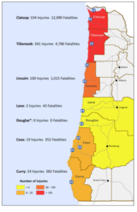
The figures on the OHA map don’t make sense. Lincoln County will suffer over 1000 dead in the event of the Big One, but only 100 injured? How can that be? In any catastrophe many more people are injuted than killed.
Is the assumption that no help will come, and that most of the injured will die of untreated wounds?
My hunch is that most people caught in the tsunami drown. Injuries elsewhere from shaking damage are going to be fewer because we don’t have many tall buildings here, especially tall old brick buildings. That’s why the much higher injury toll in Clatsop due to Astoria. And higher death toll due to the likelihood there will be no escape from the sand spit on which much of Seaside sits.
Oh and I should add Lincoln’s high fatality rate is largely due to Bayshore near Waldport, not to mention Nye Beach and low-lying Yachats.
If we suffer a 9.0 magnitude earthquake here in western Oregon the resulting tsunami will be the least of our problems. Severely damaged or destroyed roads, highways and bridges will cut off our land communications to the outside world and the power grid will suffer major failure. I’ve been through many hurricanes on the Gulf Coast and even the worst of them would pale in comparison to what would happen to people living on the coast here if and when that quake hits.
According to a geologist friend, all roads to valley will be impassable due to slides. Portland will be destroyed, so expect no help there. All bridges on the coast will be destroyed, communities will be isolated. Death toll much worse than predicted. No help from valley, we are on our own. Be prepared.