Sponsor

Pioneer Connect Premium Wi-Fi Mobile Phone Home Business Lincoln County Oregon Coast Pioneer Connect Premium Wi-Fi Mobile Phone Home Business Lincoln County Oregon Coast Pioneer Connect Premium Wi-Fi Mobile Phone Home Business Lincoln County Oregon Coast
Donate

Independent, non-profit news • Established 2019

  • Home
  • About
  • Sections
    • Community News
    • News Briefs
    • Oregon/NW News
    • Oregon Coast Today
    • Obituaries
    • Letters
    • Police/Fire News
    • A Picture Tells the Story
    • 5 Questions and a Secret
  • Events
    • Events Calendar
    • Civic Meetings Calendar
    • Sports Calendar and Results
  • Weather/Tides
    • Weather Forecast
    • WeatherLink
    • Weather Underground
    • Yachats tides
    • Waldport Tides
  • Contact
    • Sign Up
    • Guidelines for letters
    • How to submit obituaries
    • Submit a News Release
    • Submit a Photo
  • Advertise
  • Public Notices
Environment·Other Yachats Community News

Oregon releases draft of new wildfire hazard map replacing one that drew backlash in 2022

July 18, 2024
  • Facebook
  • X
  • Bluesky
  • Linkedin
  • Email
    Oregon coast fires September 2020
    Dale Voris A newly released proposed wildfire hazard map was created after the 2020 Labor Day fires that ripped through four major areas of Oregon, including the north Lincoln County community of Otis where 288 homes were destroyed. 


    By APRIL ERHLICH/Oregon Public Broadcasting

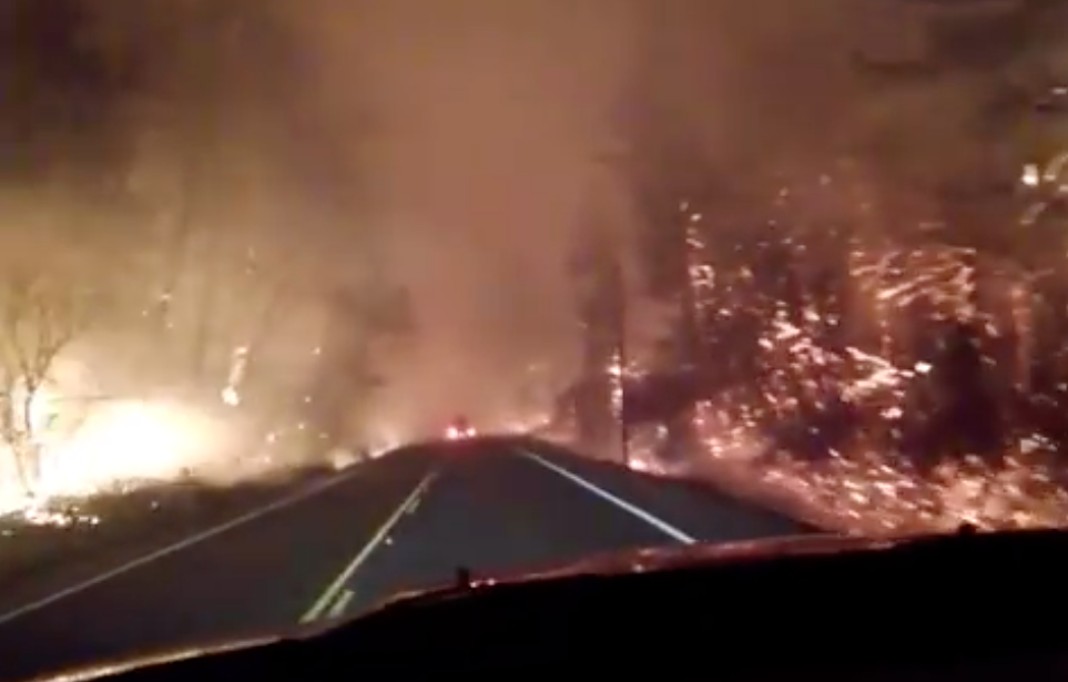
    Oregon has a new draft map illustrating which areas of the state are most susceptible to wildfires.

    Oregon State University and the Oregon Department of Forestry released the proposed wildfire hazard map Thursday. There, Oregonians can look up specific tax lots to see how susceptible they are to wildfires.

    Go to: View the interactive wildfire hazard map here

    This is Oregon’s second attempt at creating a wildfire map. State fire officials and OSU first released a map in 2022 under a tight one-year deadline set by Senate Bill 762. That first iteration received intense public backlash, particularly from property owners concerned it would affect their homeowners insurance. The state ultimately rescinded it.

    All of Lincoln County falls under low or moderate risk for wildfires according to a new fire hazard map produced by Oregon State University and the Oregon Department of Forestry.

    This time, officials spent more time on public outreach, meeting with hundreds of Oregonians in cities and towns around the state. Oregon Department of Forestry spokesperson Derek Gasperini said those meetings and other public comments played a big role in launching this new map.

    “We’re trying to not alarm folks and make sure that they have an opportunity to see it before it impacts them in any way,” Gasperini said.

    While the public has until Aug. 18 to comment on this new map, Gasperini said people should contact his department with feedback any time. The best way to comment is by emailing hazardmap@odf.oregon.gov.

    This new map doesn’t look much different than the previous version. It has a new name: This time it’s called a wildfire hazard map, instead of a wildfire risk map. There are also fewer wildfire hazard levels that properties can fall into. There are now three levels instead of five: low, moderate and high.

    A map showing low, moderate and high wildfire risk areas and another showing which areas are in the wildland urban interface.
    Oregon released a preliminary wildfire hazard map Thursday.  Left: The map groups land across the state into three wildfire hazard levels: low, moderate or high. Only high-risk properties that are also in the wildland-urban interface could face new building code and landscaping regulations. Right: This view of the map highlights areas that fall into the wildland-urban interface, usually sparsely populated areas just outside of cities.
    Similar to the initial version, this new wildfire map won’t impact homeowners insurance plans. State law prohibits insurance providers from using it to determine premiums or coverage. Most insurers already have their own maps and databases to make those determinations.

    The new map also lowers wildfire risk for many hay and pasture lands, since those areas are usually irrigated or grazed much of the summer. Farmers and agriculture advocates are pushing for dropping still more irrigated farmlands from the high hazard level before the map is made official.

    There’s little data or research on irrigated farmland and wildfire risk. Still, researchers say flames tend to avoid those moist regions.

    “It’s pretty obvious that often, maybe even most of the time, those irrigated croplands do serve as a pretty functional fire break because the fuels are wet and not burnable,” Oregon State University College of Forestry assistance researcher Andy McEvoy said.

    Still, it’s not clear how state officials will account for farmlands that stop getting irrigated in the middle of a wildfire season — which occasionally happens in Oregon’s most drought-prone areas. The state is considering rules that would lower wildfire hazard levels for croplands that were irrigated one out of the last five years. Public hearings for that change are scheduled July 31 and Aug. 1.

    Like the previous map, the new wildfire hazard map illustrates which properties fall into a wildland-urban interface, which are sparsely populated areas where cities transition into wildlands. The wildland-urban interface covers less than 5% of the state, according to OSU researchers.

    McEvoy has been part of the wildfire map-making process since it first began in 2021. He says the wildfire hazard map serves three major purposes: to educate the public about their wildfire exposure, to help lawmakers prioritize fire adaptation and mitigation resources in the most vulnerable areas, and to identify which areas will need to implement new building and landscaping regulations.

    Only properties that fall into high-hazard zones in the wildland urban interface will have to follow those new building and landscaping regulations. They could require new buildings and building additions to be built with fire-resistant materials, like metal roofs or cement siding. They could also require properties in those areas to maintain a “defensible space” — like by removing lower branches from tall trees, spacing trees far from power lines and storing lumber far from buildings.

    Once the map is finalized in October, the state’s Building Code Division will begin its administrative process for creating new building codes, and the Oregon State Fire Marshal will begin creating rules for defensible space. Both processes will have opportunities for public comment.


    More info: The draft maps can be viewed online on Oregon Explorer and the Department of Forestry will accept comment on them through Aug. 18. Comments can be sent to hazardmap@odf.oregon.gov.

    1 Comment Leave a Reply

    1. azire says:
      July 20, 2024 at 2:47 pm

      Creeks/rivers w/beavers also may act as a fire break, somewhere for a variety of wildife to shelter & a reservoir of plants to help regrowth of native plants once a wildfires are out. https://environment-review.yale.edu/beavers-can-help-protect-streamside-vegetation-wildfires

    Comments are closed.

    Pioneer Connect Premium Wi-Fi Mobile Phone Home Business Lincoln County Oregon Coast
    ACE Hardware Walport Oregon Coast
    Lincoln City Local Government Working for You We Want Your Feedback Lincoln County Oregon Coast
    Oregon State University Hatfield Marine Science Visitor Center Newport Oregon
    Sweet homes vacation rentals Help Wanted Oregon coast
    AARP Foundation Tax-Aide Volunteers Join our team Lincoln County Newport Oregon
    David Gomberg State Representative Oregon
    Samaritan House Family Shelter Dancing with the Coastal Stars Newport Performing Arts Center Newport Oregon Coast
    Tanner Insurance Devoted Health Plans Medicare Advantage Lincoln County Oregon Coast
    Yachats Lions Club Thrift Store Yachats Oregon Coast
    Literary Arts Timothy Snyder Arlene Schnitzer Concert Hall Portland Oregon
    Yachats Chamber of Commerce Visit Yachats Oregon Coast
    Charlotte Lehto Insurance Agency Farmer's Insurance Lincoln County Oregon Coast
    Newport Farmers Market Newport Oregon Coast
    Dahl Disposal Better Bark and More Waldport Oregon Coast
    Lincoln City Cultural Center Turkish Rugs Show and Sale Lincoln County Oregon Coast
    Waldport Chamber of Commerce Memberships Lincoln County Oregon Coast
    Oregon Coast Aquarium Puffin Plate Newport Oregon
    Samaritan Health Services Samaritan Orthopedics Program Lincoln County Oregon Coast

    Letters from readers

    Look at Medicare Advantage plans carefully before making a decision

    Lincoln County has benefitted from Hall’s service for 20 years

    Jacobi urges voters to not sign Hall recall petition

    More letters


    Obituaries

    Marie Jones of Newport

    Rebecca L. Bloch of Yachats

    Sandra Lee Dunn of Yachats

    More obituaries

    Civic Calendar

    Oct 20
    4:00 pm - 7:00 pm

    Newport City Council work session and regular meeting

    Oct 21
    10:00 am

    Southwest Lincoln Water People’s Utility District board

    Oct 21
    2:00 pm - 4:00 pm

    Yachats Planning Commission monthly workshop and meeting

    Oct 27
    6:00 pm - 8:00 pm

    Newport Planning Commission work session and regular meeting

    Nov 4
    2:00 pm - 4:00 pm

    City of Yachats Parks & Commons Commission

    Nov 6
    7:00 pm - 9:00 pm

    Yachats Big Band monthly concert

    Nov 10
    10:30 am - 12:00 pm

    Yachats Rural Fire Protection District board

    Nov 11
    10:00 am - 11:30 pm

    Yachats Planning Commission monthly workshop meeting

    Nov 11
    2:00 pm - 3:30 pm

    Yachats Public Works & Streets Commission

    Nov 11
    5:00 pm - 8:00 pm

    Lincoln County School District board of directors

    View Calendar

    © 2025 Lincoln Chronicle. All rights reserved.

    • Home
    • About
    • Sections
      • Community News
      • News Briefs
      • Oregon/NW News
      • Oregon Coast Today
      • Obituaries
      • Letters
      • Police/Fire News
      • A Picture Tells the Story
      • 5 Questions and a Secret
    • Events
      • Events Calendar
      • Civic Meetings Calendar
      • Sports Calendar and Results
    • Weather/Tides
      • Weather Forecast
      • WeatherLink
      • Weather Underground
      • Yachats tides
      • Waldport Tides
    • Contact
      • Sign Up
      • Guidelines for letters
      • How to submit obituaries
      • Submit a News Release
      • Submit a Photo
    • Advertise
    • Public Notices